
Future I-66 + I-50

The TransAmerica Corridor will be composed primarily of the Eastern Gateway (I-66 + I-50), the Core Route (I-66), and the Western Gateway (I-66 + I-15).
The TransAmerica Corridor is envisioned as a unified coast-to-coast transportation system composed of three major segments: the Eastern Gateway, the Core Route, and the Western Gateway. The interconnected corridors create a continuous east-west backbone linking Atlantic ports, inland manufacturing centers, energy-producing regions, agricultural communities, and Pacific markets. The Eastern Gateway connects the Atlantic Coast at Hampton Roads and the Mid-Atlantic region into the Appalachian heartland through Virginia and West Virginia, providing critical access to maritime trade and military logistics. The Core Route forms the central spine of the corridor, extending across Kentucky, Illinois, Missouri, Kansas, Colorado, New Mexico, Arizona, and Utah, serving as a strategic freight, mobility, and economic development corridor through the center of the United States. The Western Gateway connects the corridor to the Pacific Coast through Nevada and California, linking Future I-66 to major western trade routes, inland logistics hubs, and Pacific-facing markets while also providing connections to the deepwater ports of Southern California through the I-15 system. These three components establish a true transcontinental corridor designed to enhance freight mobility, strengthen national resilience, and expand economic opportunity across rural and metropolitan America.
Future I-66 + I-50 Map
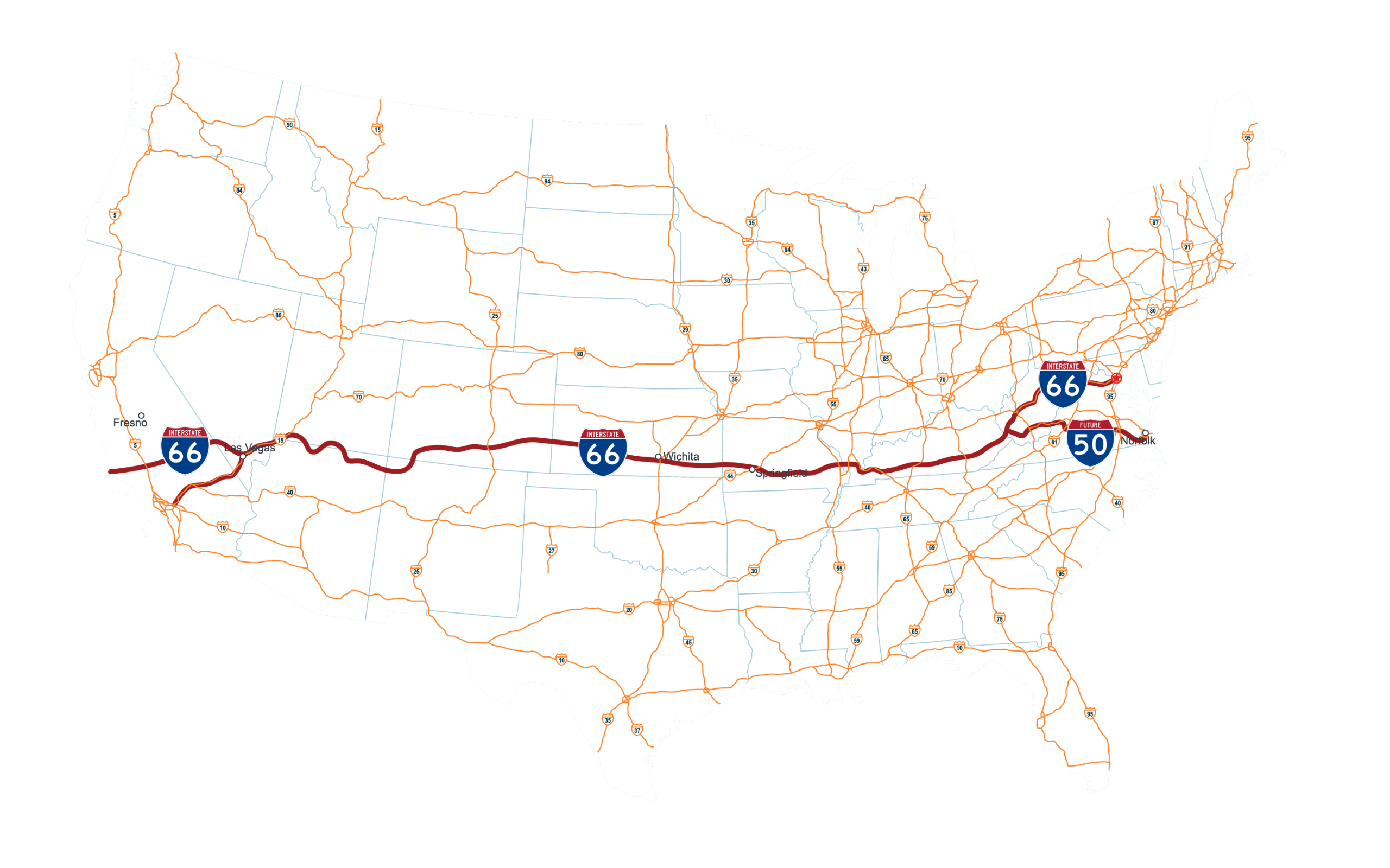
This is the route envisioned in the late 1980s. Instead of going southwest from Wichita down the Spirit Corridor, the route continues into Colorado, New Mexico, Arizona, Nevada, and California. Our goal is to add these states into the statutory route description.
Coast To Coast
The TransAmerica Transportation Corridor will allow for a single interstate spine to connect the major American ports with the center of the nation, combined with I-70 and I-40. Opportunity exists to allow for heavy truck traffic and passenger vehicle traffic to travel at speeds higher than the other east-west continental corridors.
States
Route Approved by Congress
Section 1105 © of the Intermodal Surface Transportation Act of 1991 (105 Stat. 2032) is amended at the end of paragraph (3) and the National Highway System Designation Act of 1995 (Public Law 104-59-November 28, 1995) Section 332 (a-1-A) is amended as follows:
East-West Transamerica Corridor commencing on the Atlantic Coast in the Hampton Roads area going westward across Virginia to the vicinity of Lynchburg, Virginia, continuing west to serve Roanoke and then to a West Virginia corridor centered around Beckley to Welch as part of the Coalfields Expressway described in section 1069(v), then to Williamson sharing a common corridor with the I-73/74 Corridor (referred to in item 12 of the table contained in subsection (f)), then to a Kentucky Corridor centered on the cities of Pikeville, Jenkins, Hazard, London, Somerset; then generally following the Louie B. Nunn Parkway corridor [I-66] from Somerset to Columbia, to I-65; then to Bowling Green, Hopkinsville, Benton, and Paducah, into Illinois, and into Missouri and exiting western Missouri and moving westward across southern Kansas.
In addition to the above route language set by Congress, the TransAmerica Transportation Corridor will bring the current I-66 westward along Corridor H, then carry I-66 down the current I-79 (double badged as I-79/66) until it reaches Charleston, WV, where I-66 will be carried south along the current Corridor G, until reaching Williamson, WV. The current US 460 will be the primary route linking Pikeville, KY to the Port of Virginia at Norfolk, VA, possibly re-designated and upgraded to Future I-50. This will allow for the ports at both Norfolk and Baltimore to be linked into the East-West TransAmerica Corridor system.
Purpose + Need
A new transportation corridor will need to have efficient connections with seaports (and possibly river ports) to be effective. More than 90% of the nation’s international trade volume moves through its seaports, and the volume of exports is expected by the maritime industry to triple over the next 25 years. There is a clear need to find ways to move goods to and from the ports more efficiently. In effect, the role of the East-West TransAmerica Corridor in improving the efficiency of goods movement depends on the effectiveness of the intermodal linkages provided with the ports and key domestic market areas.
Ports represent the intermodal linkages for the transfer of cargo between highway and rail facilities, which might be provided in the East-West TransAmerica Corridor and the maritime industry. Effective landslide access is critically important, and the trend in terminal facilities is to bring rail into container areas of the port facility. Available shoreside locations for the expansion of intermodal facilities at the ports are diminishing. However, container yards can be moved away from the waterfront and can provide strong surface linkages between truck and rail if located in areas readily accessible to both modes. A greater emphasis in bi-modal shipments of cargo is to be anticipated in the East-West TransAmerica Corridor in the 21st century. In addition, cargo shipping innovations based on “just-in-time” concepts require efficiency in intermodal linkages.

The TransAmerica Corridor's approved statutory route serves the following populations:
Hampton Roads, VA (Metro Area) — 1,800,000
Petersburg, VA — 33,458
Lynchburg, VA — 79,009
Roanoke, VA (Metro Area) — 315,251
Clifton Forge, VA — 3,555
Beckley, WV — 17,286
Welch, WV — 3,590
Williamson, WV —3,042
Pikeville, KY — 7,754
Hazard, KY — 5,263
London, KY — 8,053
Somerset, KY (Micro Area) — 11,924
Glasgow, KY — 15,014
Bowling Green, KY (Metro Area) — 185,682
Hopkinsville, KY — 31,180
Paducah, KY (Metro Area) — 103,481
Cape Girardeau, MO (Metro Area) — 100,842
Van Buren, MO — 786
Springfield, MO (Metro Area) — 500,000
Joplin, MO (Metro Area) — 207,131
Pittsburg, KS — 20,637
Wichita, KS (Metro Area) — 400,991
Tucumcari, NM — 5,278
Albuquerque, NM (Metro Area) — 923,630
Flagstaff, AZ (Metro Area) — 145,161
Los Angeles, CA (Metro Area) — 18,300,000
San Diego, CA (Metro Area) — 3,200,000
Total
26,427,998 Route Population
I-70 Route Population: 20.40 million
I-40 Route Population: 21.75 million
The TransAmerica Corridor's amended statutory route serves the following populations:
The I-66 + I-50 Dual Gateways: 8,943,731
Washington, DC (Metro Area) — 6,465,724
Front Royal, VA — 15,873
Weston, WV — 3,943
Charleston, WV (Metro Area) — 203,000
Hampton Roads, VA (Metro Area) — 1,800,000
Petersburg, VA — 33,458
Lynchburg, VA — 79,009
Roanoke, VA (Metro Area) — 315,251
Clifton Forge, VA — 3,555
Beckley, WV — 17,286
Welch, WV — 3,590
Williamson, WV —3,042
The I-66 Core TransAmerica Corridor: 2,000,878
Pikeville, KY — 7,754
Hazard, KY — 5,263
London, KY — 8,053
Somerset, KY (Micro Area) — 11,924
Glasgow, KY — 15,014
Bowling Green, KY (Metro Area) — 185,682
Hopkinsville, KY — 31,180
Paducah, KY (Metro Area) — 103,481
Cape Girardeau, MO (Metro Area) — 100,842
Van Buren, MO — 786
Springfield, MO (Metro Area) — 500,000
Joplin, MO (Metro Area) — 207,131
Pittsburg, KS — 20,637
Wichita, KS (Metro Area) — 400,991
Dodge City, KS — 27,788
Garden City, KS — 28,151
Lamar, CO — 7,687
La Junta, CO — 7,322
Walsenburg, CO — 3,049
Alamosa, CO — 9,871
Pagosa Springs, CO — 1,571
Durango, CO (Mirco Area) — 55,000
Aztec, NM — 6,201
Farmington, NM — 45,968
Shiprock, NM — 7,718
Page, AZ — 7,440
Kanab, UT — 5,470
Fredonia, AZ — 1,323
Colorado City, AZ — 2,478
St. George, UT (Metro Area) — 213,000
The I-66 + I-15 Dual Gateways: 24,243,657
Las Vegas, NV (Metro Area) — 2,398,000
Porterville, CA — 63,157
San Luis Obispo, CA (County) — 282,500
Los Angeles, CA (Metro Area) — 18,300,000
San Diego, CA (Metro Area) — 3,200,000
Total
35,188,266 Route Population
I-70 Route Population: 20.40 million
I-40 Route Population: 21.75 million
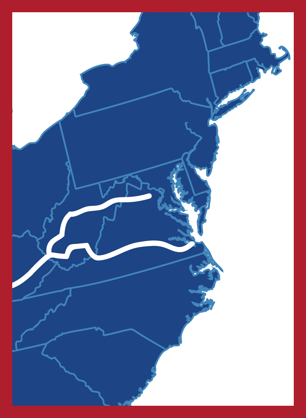
Eastern Gateway I-66 + I-50
The Eastern Gateway of the TransAmerica Corridor establishes the dual I-66/I-50 designation as the means of resolving decades of unfinished statutory routing in Virginia and West Virginia while preserving the historical congressional authorization of Future I-66 dating to the 1991-1995 legislation. Future I-66 forms the northern leg of the gateway, linking the deepwater port complex at Baltimore to Washington, DC, then running west to Front Royal, Virginia, and on into West Virginia through Weston, down to the state capital at Charleston, and finally to Williamson at the Kentucky border. This routing reflects the original statutory intent of connecting the Mid-Atlantic port system to the Appalachian interior, an intent that was never fully numbered or completed by Congress despite the underlying authorization remaining in force.
Future I-50 forms the complementary southern leg, originating at the Port of Norfolk and running through Lynchburg and Roanoke before turning north along the US 220 corridor to a junction with I-64 near Beckley, West Virginia. From there it continues south through Welch and over to Williamson, where it merges into I-66, unifying the two eastern approaches into a single corridor identity before the route continues westward toward Kentucky, Missouri, and the rest of the statutory alignment. The dual numbering lets TransAmerica Corridor resolve the numbering logic for two distinct port-to-interior approaches, Baltimore-Washington via the north and Norfolk-Roanoke via the south, without relocating the historically designated I-66 line south of I-64, and it sets up the Williamson merge point as the structural anchor of the entire Eastern Gateway concept.
The Core Route I-66
The Core Route of the TransAmerica Corridor (Future Interstate 66) represents the central east-west spine of the larger TransAmerica Corridor system, linking Appalachia, the Midwest, the Great Plains, the Four Corners region, and the Intermountain West. Entering Kentucky from West Virginia near Williamson and Pikeville, the corridor serves communities including Hazard, London, Somerset, Bowling Green, Hopkinsville, Benton, and Paducah before crossing the Ohio River into southern Illinois. This segment provides a direct connection between many of the nation’s rural and emerging economic regions while linking them to major interstate systems such as I-75, I-65, I-24, and I-57. The route was originally designated by Congress as part of High Priority Corridor 3, the East-West TransAmerica Corridor, to improve mobility, freight movement, economic development, and national connectivity across underserved portions of the country.
From Illinois, the corridor continues through Missouri and Kansas before turning southwest into Colorado, New Mexico, Arizona, and Utah. Along this western alignment, the route would connect agricultural regions, energy-producing areas, manufacturing centers, tribal nations, tourism destinations, and growing logistics hubs while creating a new transcontinental freight corridor between the nation’s existing I-70 and I-40 systems. The western states segment links communities such as Springfield and Wichita, continues through southeastern Colorado and northwestern New Mexico, traverses the Four Corners region near Farmington and Shiprock, crosses northern Arizona through Page, and reaches southern Utah near Kanab and St. George. These states form the backbone of a future coast-to-coast transportation corridor that would strengthen national supply chains, improve interstate access for rural America, support economic diversification, and provide an additional strategic freight route across the United States. The corridor’s western expansion concept has been incorporated into TransAmerica Corridor planning as part of a broader twelve-state vision connecting the Atlantic Coast to the American West.

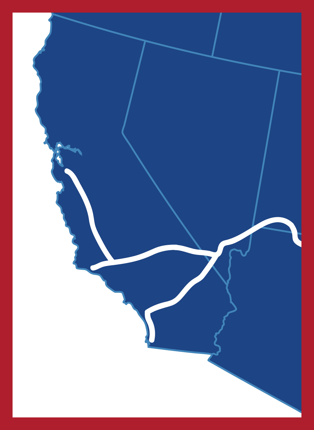
Western Gateway I-66 + I-15
The Western Gateway of the TransAmerica Corridor represents the convergence of two nationally significant transportation systems: Future I-66 and I-15. Beginning near St. George, Utah, the corridor follows a shared alignment with I-15 southward through the rapidly growing Intermountain West to Las Vegas, Nevada, creating a direct connection between the TransAmerica Corridor and one of the nation’s fastest-growing metropolitan regions. This segment serves as a critical multimodal gateway linking the interior United States with the major population centers and freight networks of the Southwest. From Las Vegas, Future I-66 utilizes the Clark County 215 Beltway before joining Future I-11, continuing northwest toward Beatty, Nevada. The route then turns west across the Mojave Desert toward Olancha, California, where it follows the eastern edge of the Sierra Nevada Mountains before reaching the agricultural and logistics centers of Porterville and California’s Central Valley. From there, the corridor extends westward to San Luis Obispo, establishing a Pacific terminus and creating a direct east-west connection between the Atlantic and Pacific coasts. The western extension concept is reflected in TransAmerica Corridor route planning documents and future corridor mapping efforts.
The Western Gateway also benefits from its connection to the established I-15 trade corridor, which serves as the southern branch of the TransAmerica Corridor system. Through Las Vegas, I-15 provides direct access to the major deepwater ports of Long Beach and San Diego, connecting international maritime commerce with inland freight markets across the American heartland. Together, the I-66 and I-15 systems create a strategic freight distribution network that links California ports, western energy resources, agricultural production regions, and growing inland population centers with the broader TransAmerica Corridor stretching eastward across the nation. This dual-gateway concept strengthens national supply chain resilience, expands market access for rural and emerging regions, and supports the long-term vision of a modern transcontinental transportation corridor connecting America’s coasts through a unified interstate system. The corridor’s western relationship with Future I-11 and the broader Congressional Future Interstate network is illustrated within the CAFI corridor system map.
Future I-66 and I-50 FAQs
The corridor creates a direct east-west connection linking gateway regions representing approximately 35.2 million people, major Atlantic and Pacific ports, national defense assets, manufacturing centers, agricultural regions, and freight distribution hubs.
This interstate highway was chosen in the late 1980s for the interstate spine or “middle corridor” route not because of its similarity to the old Route 66, but because of its connection to Washington, DC and Baltimore. Creating a westward expansion along it was the most obvious choice at the time, and even for the purpose and need today. Congress then decided to start the East-West TransAmerica Corridor route at Norfolk, Virginia. The statutory route language approved by Congress required the route number 66 to be moved (in the 1990s) from northern Virginia to the US 460 route, but this action was never done. It would have also created a number problem with a higher number south of I-64. Today, the TransAmerica Corridor, Inc. organization recommends leaving I-66 as it is, designating a new number (possibly I-50 or I-56) from Norfolk, Virginia to Williamson, West Virginia, merging into I-66 at that area. This would allow for dual gateways on the east coast (I-66 and I-50) and dual gateways on the west coast (I-66 and I-15). The whole point of the East-West TransAmerica Corridor / TransAmerica Transportation Corridor is the connection between the major ports on the west coast and the east coast.
Yes and no. The statutory route language assigned by Congress is mostly concerned with logical termini.
The original 1994 TTC study update will show what modes of transportation could be economically viable today. The TTC study won’t be concerned with final alignments per se, but on the viability of the concepts (MoDOT was the lead for all 12 states on the Steering Committee in 1994). PEL studies and Environmental Impact Studies, among other tools, will be used to show a precise and final alignment.
US 460 has received upgrades as a partially controlled access rural expressway since the 1990s. Sections of US 460 remain to be upgraded as a partially controlled access rural expressway. Corridor H is under study for its final 8 miles to the Virginia state line, which will be done by the early 2030s. This will allow I-66 to be carried westward to Weston, WV for the first time in the history of this project (though Corridor H is not directly related to the TAC). Kentucky has also finished most of the old I-66 route from Somerset to Hopkinsville as a partially controlled access rural expressway. US 60 in southern Missouri has also been upgraded to partially controlled access rural expressway since the 1990s. One of the alternate alignments considered for entering Missouri was a new bridge facility connecting western Kentucky at Wickliffe. This was rejected due to the cost, engineering problems due to lack of access to bedrock in the New Madrid earthquake zone, and river traffic right-of-way. KYTC recognized that the logical termini are Paducah and Cape Girardeau, along with pointing out the Congressionally approved route language also prevented the above bridge concept from ever getting built. US 400 in southern Kansas has also some upgrades to partially controlled access rural expressways, and this is true in Kansas from the state line with Missouri almost all the way to Wichita, KS.
From the east coast to Wichita, KS, this will mostly be upgrading the current partially controlled access rural expressways to limited access controlled interstate highways, which will also require building outer roads. This is another reason the whole project is broken up into the 3 Segments of 4 states, allowing for parts of the whole to be completed as funding becomes available.